
AEROphoria

Plan your drone flights.
Keep your records together.
AEROphoria helps you check airspace and record your flights. Start with the free safety app and logbook, then explore mission planning and specialist assessment tools as your operation requires them.
What do you need for your next flight?
Check airspace and record your flights
Review the safety map and available flight information, then keep your flying records in the digital logbook.
Explore the free toolsPlan and document your operation
Explore mission planning, operational records and specialist tools for SORA assessments and supported authorisation requests.
Access depends on the module and your operation’s eligibility.
Discuss your requirementsSee the tools behind your next mission
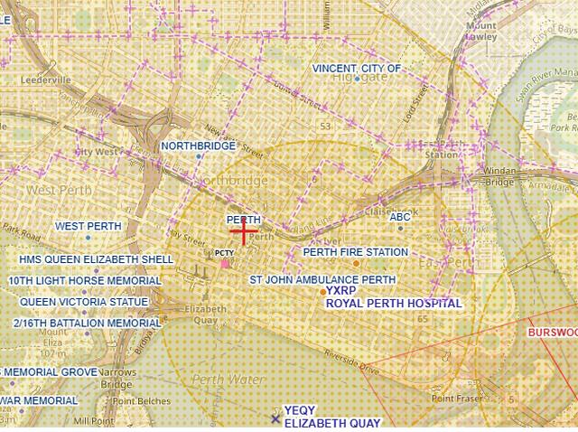
Check the airspace before you fly
Choose map layers, inspect location details and review available weather information.
- Review aerodromes and restricted or danger areas.
- View relevant map layers for your flight location.
- Keep a record of your flights in the logbook.
The map supports planning. Pilots remain responsible for checking current information, local requirements and flight conditions.
Prepare your assessment and supporting evidence
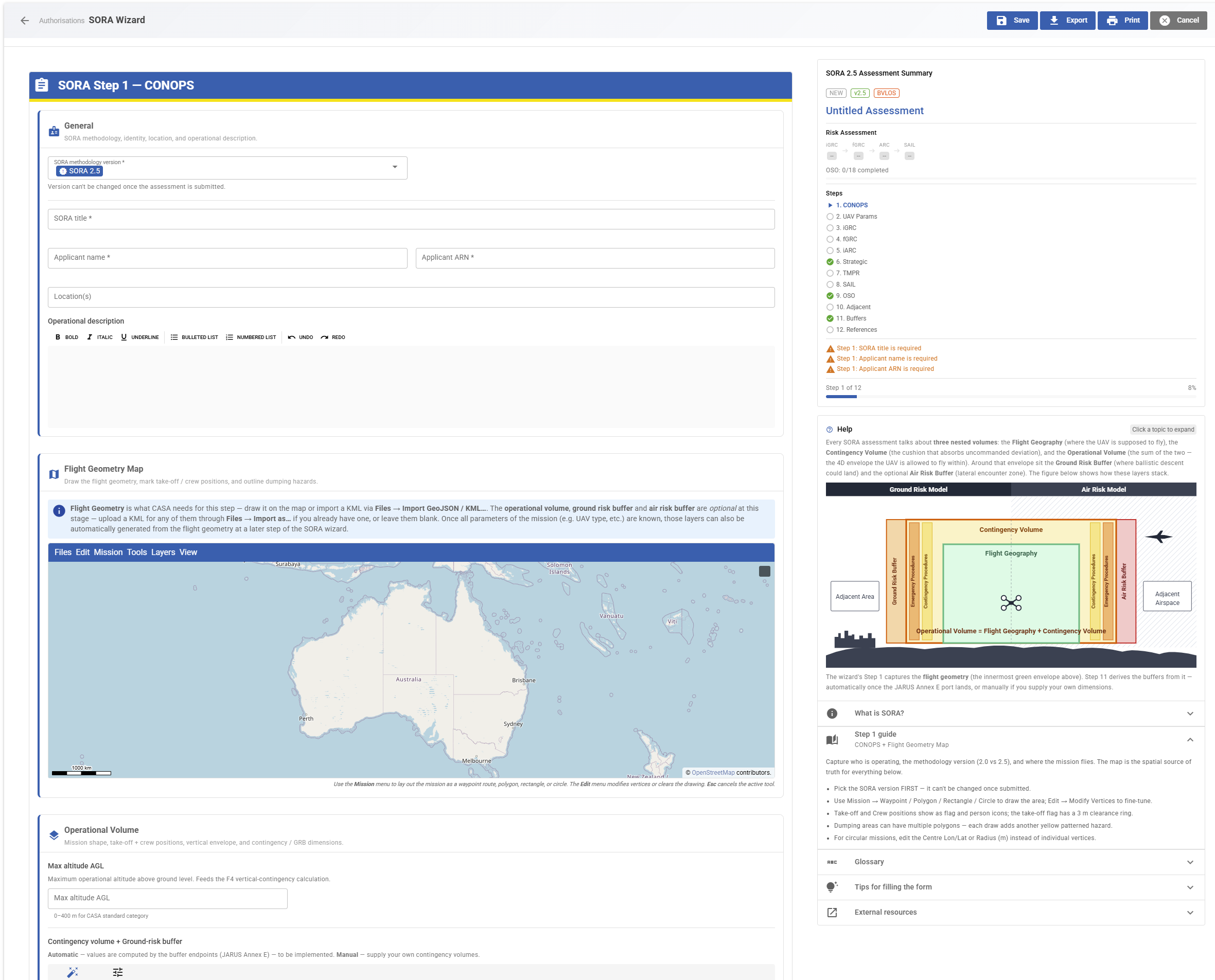
Work through AusSORA and JARUS SORA 2.0 or 2.5 assessments using structured tools.
- Work through risk calculations and population information.
- Keep supporting evidence and case revisions together.
- Trace results to the relevant rule version.
Specialist access requirements apply. Assessment tools support an application; the relevant authority makes the authorisation decision.
From the airspace map to your operational records
Select a screenshot to see a larger view. Interfaces shown are examples; module access varies.
Start free. Choose additional tools for your operation.
Some tools are part of the free app. Others have account, module or eligibility requirements.
Check airspace and keep your flight records. Open the app →
Availability depends on your account and the module. Ask us which tools fit your operation.
An applicable plan, beta access, add-on or tailored arrangement may be required.
For eligible enrolled operators and supported operations. The relevant authority decides each request.
Request access through participating zone managers. These permissions are separate from CASA authorisations.
Discuss the tools your operation needs
Tell us what you fly, where you operate and what you need to document. We can confirm the available modules and their access requirements.
Risk assessments
Structured SORA and AusSORA workflows with supporting evidence and assessment revisions.
Operational records
Aircraft, equipment and maintenance records alongside flight and team information.
Managed zones and analysis
Participating-zone permit workflows and specialist imagery analysis modules.
Your questions, answered
What can I use for free?
The core drone safety app and digital logbook are free. Advanced operational features may require beta access, an add-on or another plan. Contact UXMachines for current availability and pricing.
Can I use AEROphoria outside Australia?
The app is currently accessible only from Australia. International visitors can explore the platform here and contact UXMachines about their needs.
Which specialist features can I access now?
Access depends on the module and your operation. Ask UXMachines to confirm availability before choosing a specialist workflow. Extended datasets, deeper BVLOS workflows, autonomy, Drone-in-a-Box integration and additional authority connections are development directions, not promises of current features.
Can AEROphoria approve my flight?
Supported authorisation workflows are available only to eligible enrolled operators and for supported operations. The relevant authority makes the decision. You remain responsible for a safe and lawful flight.
Is AEROphoria part of CASA or Airservices Australia?
No. UXMachines independently develops AEROphoria. Participation in CASA’s drone safety app and authorisation programs does not mean CASA or Airservices Australia owns or endorses the product.
Does the map show every nearby aircraft?
No. Community-supplied aircraft-position data has incomplete coverage, particularly for low-flying aircraft. An empty map does not mean the airspace is clear. This information supports situational awareness and is not an authoritative source for flight decisions or regulatory submissions.
Start with your next flight.
Explore the free safety app and digital logbook.
Built from our own experience operating drones
AEROphoria grew from our need to plan and document UAV operations. We develop it in Western Australia, drawing on our experience building software and operating drones in the field.
Download the product brochure →